
When the dishes and windows rattled and the house shook for 10 to 15 seconds my first thought was a major train derailment. But then I realized it might have been an earthquake.
An earthquake in North Idaho! Sure enough, the USGS reported a quake within a few minutes on their website. A 4.1 magnitude earthquake 22 km southeast of Sandpoint (vicinity of the Green Monarchs) at 7:32 p.m. on Thursday, April 23.
 |
|
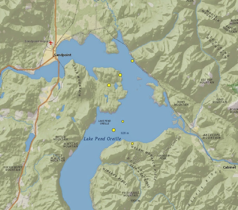
Six earthquakes happened within 17 hours (dots south to north): Thursday, April 23 at 7:46 p.m.; Thursday at 7:32 p.m.; Thursday at 8:22 p.m.; Thursday at 10:43 p.m.; Friday, April 24 at 1:28 a.m.; and Friday at 11:39 p.m. (Source: USGS)
|
Then a swarm of five earthquakes happened over the next 17 hours, all in the vicinity of Lake Pend Oreille. The USGS revised the data by Saturday to reflect new magnitudes, including reducing the initial earthquake to magnitude 3.7. Revisions often are made as more data is gathered from seismograph stations around the world.
The second and third earthquakes were smaller and less likely to be felt. The second earthquake was magnitude 1.9 at 7:46 p.m. and the third was a magnitude 1.8 at 8:22 p.m. The fourth quake at 10:43 p.m. was originally classified as a magnitude 4.2 but later downgraded to magnitude 3.9. The fifth quake registered a magnitude of 3.3 at 1:28 a.m. on April 24 and the sixth quake registered a magnitude of 2.7 at 11:39 a.m. The larger earthquakes were felt by people across North Idaho and into northeastern Washington and northwest Montana.
North Idaho isn’t a common place for earthquakes but there have been other low-intensity quakes over the years. The largest earthquake recorded was centered near Sandpoint on Nov. 1, 1942 and was an intensity VI (or magnitude 5).
Before I continue I should mention how earthquakes are measured. There are three different scales for measuring earthquake size. The most commonly heard of is the Richter magnitude scale.
The Richter scale is based on ground motion recorded on a seismograph. The scale is logarithmic so each whole magnitude is a ten-fold increase in wave amplitude and a thirty-three-fold increase in energy. A magnitude 2.0 earthquake has the energy equivalent of a lightning bolt while a magnitude 4.0 earthquake has the energy equivalent of 100 tons of TNT.
The other common scale is the Mercalli intensity scale which is based on the amount of damage. The scale is subjective and utilizes Roman numerals. For example a intensity III earthquake is felt indoors, seems as if a heavy truck is passing and standing automobiles sway on suspensions. An intensity IV earthquake awakens some sleepers and causes dishes and windows to rattle.
The third scale is the seismic-moment magnitude scale and takes into account the amount of slip, length of rupture, depth of rupture and rock strength. This scale is most often used by seismologists.
In the last 35 years there has only been a handful of earthquakes in Bonner and Boundary County, so the six last week nearly doubled that total in Bonner County.
Boundary County had a swarm of earthquakes in 1984 spaced over six months. A magnitude 4.1 earthquake was recorded near Queen Mountain on July 30, then a magnitude 3.2 south of Copeland on Nov. 27 and a magnitude 2.0 near the junction of Highway 1 and 95 on Dec. 26. More recently a magnitude 2.0 earthquake was recorded on Oct. 21, 2004 near the Montana border along the Kootenai River.
The six earthquakes between 1988 and 2003 in Bonner County ranged in magnitude from 2.0 to 3.5.
While most earthquakes happen at plate boundaries, active rifts or collision zones, some do happen elsewhere–like North Idaho. These earthquakes are called intraplate earthquakes and account for five percent of earthquake energy released in a year.
Often intraplate earthquakes occur along ancient fault zones and the Hope Fault is considered to be part of the ancient Lewis and Clark Zone. The Hope Fault roughly follows a line from Ponderay to East Hope and beyond into Montana. Some researchers think the Hope Fault is the southern edge of the slab of rocks that moved eastward off the Kanisku batholith to expose the modern Selkirk Mountains.
Different factors can cause intraplate earthquakes: forces applied to plate boundaries can cause zones of weakness to break within the plate; shearing between the lithosphere and asthenosphere; or the crust readjusting to loads from glaciers or sedimentary piles. North Idaho was subjected to large glaciers during the last ice age and glacial rebound (the crust slowly springing back) can take thousands of years.
Intraplate earthquakes also tend to have a shallow focus (the point where the rock ruptured within the earth) of less than 20 km. The six earthquakes last week ranged between 20.5 km and 8.2 km deep.
The reason behind the earthquakes is still unknown. There may not be another earthquake for decades or these could be foreshocks to larger earthquakes yet to come. Either way, I was excited to feel an earthquake in North Idaho and be a part of geologic history!


